KHINALIG VILLAGE

The village of Khinalig is located in the North West of Azerbaijan, in Guba District, 230 km from the capital Baku, at an altitude of about 2,180 metres above sea-level. Khinalig, located to the east of River Gudyalchay, is dominated by mountain scenery.

The village is surrounded by several depressions and plateaus, such as the Shahduz depression, Shahdag and Gizilgaya plateaux. The highest mountain peaks near Khinalig are Bazarduzu (4,466 m), Tufandag (4,191 m), Shahdag (4,243 m) and Gizilgaya (3,726 m). Steep cliffs and its location on the top of Shahdag, the harsh climate and the lack of land in the village make it very difficult for the people living here. However, despite the unfavourable conditions, the people of Khinalig live by carefully managing their limited natural resources.

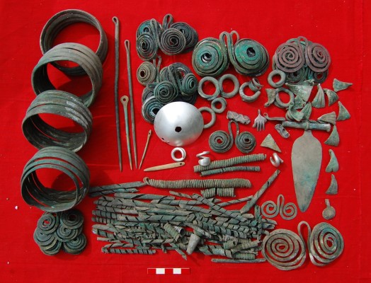
Historians believe Khinalig was first built before the modern era. Information about it can be found in the works of Strabo and Pliny. Evidence has been unearthed dating the first settlement established on the territory of Khinalig to the Early Bronze Age (late 4th millennium BC). An ancient settlement called Zangar was discovered during archeological excavations in Khinalig, as well as a Middle Bronze Age burial mound 500 metres to the east. Numerous amulets, arrowheads and various other ornaments made of bronze have been found at the excavation sites.

Khinalig was wrongly regarded as an isolated place for many years due to the lack of written sources and relations with neighbours. For the same reasons, the area was not studied or researched as an important archeological site during the Tsarist and Soviet periods and, therefore, this type of work is quite new for Khinalig. Recent research in the area proves that Khinalig is an important place to study early mountain culture in the Caucasus, starting from the Bronze and Iron ages. The analysis of the archeological findings from the area, including the topology of burial places and objects placed in graves, the methods and materials used for making tools and decorative objects, and many other elements, are testimony to the close cultural and socio-political links with other settlements on the southern slopes of the Great Caucasus Mountains, such as Gebele and Shirvan.

With the collapse of the Soviet Union in 1991, the collective farming model was abolished. All collective assets and lands were divided among the people. Most staff of the Dimitrov ‘Kolkhoz’ continued their semi-nomadic animal husbandry individually or in small groups.

Traditional transhumance practice was again interrupted during this period due to several reasons. Modernisation pressure was already creating a trend of sedentarisation among the semi-nomadic people of the region. The fall of the previous regime and future uncertainty also caused significant confusion among the people. More importantly, new state borders disrupted the transhumance routes between Dagestan Autonomous Republic and Azerbaijan.

Following a period of instability after the collapse of the USSR, the people of Khinalig stepped into a new period within the independent Republic of Azerbaijan. A new tarmac road to Khinalig made the village accessible all year round. In 2007, Khinalig State Cultural, Historical and Ethnographic Reserve was established to preserve the people’s unique architecture and living culture. In 2023, this territory was assimilated into the more extensive ‘Khinalig and Köç Yolu Transhumance Route’ State Historical, Cultural and Ethnographic Reserve.

Soviet power had a profound impact on the Khinalig people. The establishment of the Azerbaijan SSR on 28 April 1920 ushered in significant changes to their way of life. Scientific data from 1926 indicates that most Khinalig residents were living in poverty and desolation. A report from a sanitary and epidemiologic expedition sent to the village by Soviet authorities in 1934 described the sanitary conditions among the semi-nomadic people as alarming. Despite the challenging social circumstances resulting from the historical events of that period, the people of Khinalig displayed remarkable resilience and continued to practise their traditional occupations and way of life.

The situation of the Khinalig people improved under the stability brought by the Soviet regime, leading to population growth. According to statistical data, the population of Khinalig was 1,400 in 1926, 2,500 in 1976 and 2,101 in 1989. The first elementary school in Khinalig was opened in 1926, and by 1940 it had expanded to offer seven grades. In 1973, it had evolved into a full ten-grade Soviet secondary school. In 1956, the medical centre of Khinalig was established, followed by the introduction of the first telephone line and post office in 1967, and a television transmission station in 1985-1986.

In the 1930s, Stalin's collectivisation policy brought significant changes to Khinalig. All private ownership was expropriated and consolidated under the ‘Gizil Ulduz’ (‘Golden Star’) Kolkhoz in 1934, leading many affluent farmers to be repressed and exiled. The Encyclopedia Britannica defines a Kolkhoz as ‘a cooperative agricultural enterprise operated on state-owned land by peasants from several households who belonged to the collective and were paid as employees based on the quality and quantity of labour contributed.’

In the 1960s, the Dimitrov Kolkhoz was established in Khinalig, bringing together more than 50,000 sheep, making it the largest sheep farm in Azerbaijan. Khinalig, along with neighbouring villages - Griz, Alik, Jek, Haput and Galakhudat - were united under one large Kolkhoz specialising in animal husbandry, with Khinalig serving as the central hub. They nonetheless maintained the semi-nomadic tradition of animal husbandry, using the traditional Köç Yolu route between gishlags and yaylags. In 1964, the Dimitrov Kolkhoz was reorganised into the Dimitrov Sovkhoz. This new economic transformation granted Khinalig herders the right to breed their own small herds of sheep while adhering to state-imposed quotas. A Sovkhoz, according to the Encyclopedia Britannica, is ‘a state-operated agricultural estate in the U.S.S.R. organised according to industrial principles for specialised large-scale production. Workers received wages but could also cultivate their personal garden plots.’

The unification of various villages under one large cooperative promoted the exchange of cultural and ethnographic values among these communities. The expertise in breeding sheep herds and the semi-nomadic lifestyle, which had historically brought economic prosperity to the Khinalig people, enabled them to excel in the new economic system, which continued to uphold the tradition of transhumance husbandry, albeit under state ownership.

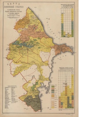
Baku Governorate was an administrative and territorial unit of the Russian Empire that existed in 1859-1920, with its centre in the city of Baku. It bordered Iran and the Governorates of  Elizavethpol (Ganja) and Dagestan. Within the Guba Uyezd, Khinalig was a part of Baku Governorate.

In the 1880s, there were 510 houses in the village of Khinalig alone, and its population stood at 2,100 in the 1890s. According to F. Schnitnikov, there were equestrian factories in the villages of Khinalig and Budug in the 19th century. V. Legkobitov called the people of Khinalig “a living history that lives among inaccessible mountains” and mentioned that they were “tall and blonde, with beautiful facial features and blue eyes.”

While the people of Khinalig continued to practise their traditional occupations during the governorate period, there were still several obstacles created by the increasing trend of transitioning to sedentary agriculture. Historically, some ‘gishlags’ of Khinalig people were also in the Mushkur and Shabran districts on the Caspian coast. The intensive development of the dye economy in Mushkur (Khachmaz) District in the 1830s to 1840s led to the occupation of these territories by sedentary farmers, which forced the people of Khinalig to use the plains of central Azerbaijan as new gishlags. Semi-nomadic people were the most exposed to military and political turmoil, which the history of Khinalig has aplenty. The frequent changes of governments, administrative and political regimes, and military operations throughout the history of Khinalig created significant obstacles for transhumance. Therefore, many semi-nomadic people have abandoned their traditional methods. Khinalig inhabitants are one of the few peoples to keep their transhumance traditions over centuries.

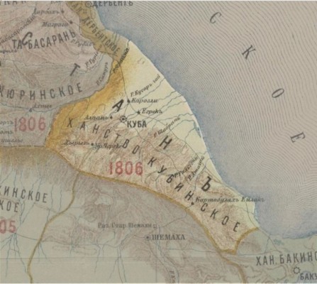
The assassination of Nader Shah led to the gradual disintegration of his lands, giving rise to small independent and semi-independent states across the former unified empire. De facto independent feudal states known as ‘khanates’ emerged in Azerbaijan. These were either partially or entirely founded and ruled by semi-nomadic dynasties. Khinalig was part of the Guba Khanate, which existed in the North East of Azerbaijan from 1726 to 1806 and was one of the most significant feudal states. While Huseynali Khan initially established the Khanate, the era under the rule of his son, Fatali Khan (1736-1789), is regarded as a period of growth and prosperity for the khanate. During Fatali Khan's 31-year reign, he consolidated territories from neighbouring states and established diplomatic relations with others. After Fatali Khan's death, the khanate weakened and was captured by the Russian Empire in 1806.

Guba Khanate was divided into ten administrative districts known as ‘mahals’. The village of Khinalig was grouped under the organisational unit of ‘Khinalig mahal’, along with several others, including Griz, Haput, Jek and Alik, and later Galakhudat. Khinalig served as the administrative centre of this mahal. In 1796, Russian military officer and later prominent historian Petr Butkov (1775-1857) wrote a brief report about the region. He described the village of Khinalig as the centre of a ‘nahiye’ (or ‘mahal’) and noted that the primary occupation of the people in the area was animal husbandry.

Caucasian Albania, an ancient country of Antiquity, was located in the eastern and southern regions of the Greater Caucasus Mountains. Remarkably, it nurtured a written culture complete with its own distinct alphabet.

Artefacts excavated at the Kimeligiberish archaeological site from Classical Antiquity closely resemble discoveries of Caucasian Albanian origin found in various other places, including Gabala, Minghechevir, Mollaisagli and Shamakhi. This resemblance leads to the conclusion that the Khinalig area had a political affiliation with Caucasian Albania. However, this was not merely a passive interaction, but an active participation in cultural and societal spheres, engaging in trade and sharing a common metaphysical and spiritual worldview with other provinces of the region. This strengthens the hypothesis that the residents of Khinalig were one of the 26 tribes that constituted the state of Caucasian Albania.

Furthermore, the palimpsest writings in the ancient Udi language (the official language of Caucasian Albania) dating back to the 6th and 7th centuries contain vocabulary that persists to this day in the contemporary Khinalug language. Today’s Udi descendants of the region, residing in the village of Nij in Gabala District, continue to use a language strikingly similar to the one found in these ancient palimpsests.

Historically, Khinalig served as a crucial crossroads for the narrow mountain routes connecting the capital of Caucasian Albania, Gabala, located on the southern slopes of the Greater Caucasus Mountains, to the North Caucasus and the Derbent region. Other minor mountain paths also converged in Khinalig. Even today, Khinalig plays an essential role as a meeting point for transhumance herders who traverse the same ancient mountain trails that their Albanian forebears followed for economic, political or even military purposes. Thus, the discovery of coins from the Sassanid era, minted in the name of Shah Khosrow II (591-628), in Khinalig is not coincidental and points to the village's robust trade connections with neighbouring regions. Moreover, coins from other mediaeval states like the Atabeks (1136-1225), the Ilkhanid Mongols (1258-1336), Ag Goyunlu (1468-1501) and the Safavids have also been uncovered in the vicinity of Khinalig village.

The Kura-Araxes culture characterises the Bronze Age in Azerbaijan with the production of bronze using the area's rich copper mines and imports from the neighbouring regions. Archeological excavations carried out in the vicinity of Khinalig village allow us to confirm that the area has been inhabited at least from the Early Bronze Age. Indeed, recent road construction and housing projects revealed some ancient burial sites and old settlements related to the Bronze Age. Artefacts collected from the archeological excavations revealed that important population movement occurred in and around Khinalig village. As there were no tools relating to agriculture, scientists suggest with high probability that the graves belong to an ancient nomadic population.

The village is inhabited by a minority ethnic group speaking a unique language – Khinalug. Despite the unfavourable conditions, the resilient people of Khinalig, who number about 1200, have managed to adapt to the land and use its limited natural resources with prudence. 

The Khinalig people comprise a distinct ethnic group who live in Khinalig village and several other parts of Quba region. This small group is believed to be descendants of the Caucasian Albanians, namely one of the 26 Caucasian Albanian tribes mentioned in ancient sources. The people's exact origin and language still pose many questions to ethnographers and linguists.

The people of Khinalig have historically been practicing transhumance, moving their livestock between yaylaqs—highland summer pastures close to their ancestral village and qishlaqs—lowland winter pastures in central Azerbaijan. The process of movement, which happens twice a year in spring  and autumn, lasts around two weeks each time. The shepherds and their flocks from Khinalig join around 7,000 people and 400,000 sheep from other nearby settlements on the seasonal movement route, which starts from Khinalig village and ends in the winter pastures of Hajigabul and Absheron. Out of this convergence, 45,000 animals and 3,200 people are from Khinalig proper, and additionally, 25,000 animals are from the buffer zone. 
 

The village of Khinalig is known all over the world for the River Gudyalchay, which flows along the mountain slopes, its glorious beauty distinguished among the steep cliffs. The area above Khinalig is covered with glaciers almost all year round.

The village is surrounded by a series of depressions and plateaus, such as the Shahduzu depression, Shahdag and Gizilgaya plateaux, and the highest peaks in Azerbaijan above 3500-4000 meter, including Khinalig, Bazarduzu, Tufandag, Shahdag and Gizilgaya. Khinalig also boasts over 5,000 years of history. Although the village is nestled on a steep mountain peak with a harsh climate, which makes it extremely difficult for living, the people of Khinalig have managed to adapt to the land and use the limited natural resources with prudence. The climate in this area does not support the growth of trees, but it is conducive to most cold-enduring varieties. As in other mountainous areas, the climate in the area where the village of Khinalig is located varies according to altitude.

High mountain areas (>2,700 m) are characterized by upland cold desert climate, while in lower territories (1,500-2,700 m) cold winter climate with abundant precipitation is dominant.

The annual temperature is 6°C, and the yearly precipitation is 575 mm in Khinalig. The maximal daily precipitation is 56 mm. Most of the rain falls in spring, summer, and autumn. The midsummer and winter months are relatively dry. In winter, precipitation falls and accumulates mainly in the form of snow. Melting of snow begins in mid-March, increasing the water in the mountain streams. Floods are common during warm seasons. Intensive foraging can be accompanied by rain, increasing the peak and duration of floods.

Around the village, there are many springs and more than ten caves. These caves are mainly composed of lawn breccia karsts. These are sedimentary breccia that consists of shattered fragments of minerals or rock cemented together by a fine-grained matrix. Common features of all the caves include smooth floors and indented ceilings, as well as visible traces of water. Water entering the cave from outside, mainly from above, gradually accumulates on the floor of the caves to form small pools, which only flows out once the pools are full. As a result, a certain amount of water accumulates in small pools and stays for some period.

Although there are only a few landscape types in and around the village of Khinalig, since it is located in a high mountainous area, vertical zoning is clearly visible. Alpine and subalpine meadows are widespread in the areas close to Khinalig and are the main habitats in its ecosystem. These meadows are spread both above and below the village, mainly at altitudes of 1,800-3,200 m. The mountain meadow ecosystem in the area contains mainly subalpine and alpine plants.

Into enchanting forests

There is a forested area close to the yaylag area (summer pastures), not far from the village of Khinalig at an altitude of 2,300 metres, which is a rare phenomenon for this subalpine zone. This area is called Mugoz and considered sacred by the Khinalig people. The locals protect this small forest fragment, where felling trees is taboo for the community members. They agree that the forest fragment must be protected permanently, and there are even some religious beliefs surrounding the issue. Similarly, hunting of the surrounding area’s East Caucasian tur (Capra cylindricornis) and Caucasian snowcock (Tetraogallus caucasicus) is forbidden by the local community.

Wander into the wild

The wildlife near the village of Khinalig is rich, consisting of many valuable species. East Caucasian tur (Capra cylindricornis), Caucasian chamois (Rupicapra rupicapra subsp. Caucasica), Bezoar ibex (Capra aegagrus aegagrus), mountain goat (Capra aegagrus hircus), lynx, brown bear and wild boar (Susscrofa), as well as different types of falcons and eagles, which live in this area, are protected by the state. The Khinalig people also have certain spiritual beliefs regarding some of the animals and birds that inhabit the areas. The locals are respectful towards nature, by taking and giving back is balanced in a way that is always sustainable. Various taboos on hunting certain animals (like Caucasian snowcocks) and felling trees, which are rare at that altitude, are interesting phenomena developed throughout centuries to protect the surrounding nature through beliefs.

Land of rushing rivers

Near the village of Khinalig flow the rivers Gudyalchay, Khinaligchay and Michek. The first two are abundant, while the latter dries up in the summer months. All rivers are fed by snow and rainwater and partly by groundwater. River Gudyalchay has as a very large riverbed, with many ditches that irrigate the meadows of Khinalig village, which are located near the riverbed. The Gudyalchay and Gusarchay rivers flow through glacial U-shaped trough valleys in their upper reaches and flow through box-shaped gorges with steep slopes in the middle reaches. The total length of the Gudyalchay canyon is 13 km. In the evenings, this canyon becomes a place of mysticism and wonder as low clouds rush in and shroud the landscape in mist.

Versatile plants

The use of wild plant species is significant in the lifestyle of the Khinalig people, who use yaylags and gishlags for the seasonal movements. Many plants in these areas have been used not only in local cuisine and for household items, but also as medicinal plants. The wild plants’ growing season, distribution and use, both in the household and for medical purposes, all hold an important place in the traditional knowledge of the Khinalig people, which is widely applied even to this day. In most cases, these plants are taken directly from nature.

Partly protected by Shahdag National Park, the high mountain areas around the village of Khinalig, perched picturesquely in the Greater Caucasus Mountains, are ideal to see the best of the region’s birds, including endemics to the Caucasus region. Previously too remote for many tourists, improvements in access have now put Khinalig firmly on the tourist map of Azerbaijan as one of its unmissable sights. The sparsely vegetated mountainous terrain surrounding it is a great place to look for the Caucasian snowcock, Guldenstadt´s redstart, alpine accentor, rock thrush and lammergeier (or ‘bearded vulture’).

Target species

Alpine accentor (Prunella collaris)

Caucasian snowcock (Tetraogallus caucasicus)

Green warbler (Phylloscopus nitidus)

Guldenstadt’s redstart (Phoenicurus erythrogastrus)

Lammergeier (Gypaetus barbatus)

Wallcreeper (Tichodroma muraria)

Red-fronted serin (Serinus pusillus)

Rock thrush (Monticola saxatilis)