Sites

It is believed that the history of Ibrahim Khalil Cell dates back to the end of the 18th century and the beginning of the 19th century. It is located 4 km north of Khinalig.

The cell, which used to be located on the left side of Deyrmanchay, was completely destroyed in 2003 due to a landslide. After that, it was rebuilt in a safer place using stones from the monument.

This is the most recent among the Khinalig tombs, located in the lower neighbourhood cemetery. Built in commemoration of Ahmed Efendi, preacher of Islam, the tomb dates back to the late 19th and early 20th centuries. Later, another tomb was built over the site.

This sacred site is one of the most visited places in Khinalig, a sanctuary mainly frequented by people with nervous diseases. It is believed to help children with epilepsy - according to a local belief, children must sleep here for several hours, after which the symptoms will disappear.

The Shrine of Mohuj Baba dates back to the 18th century. According to reports, Baba (‘Old Man’) Mohuj, who worked as a doctor, treated patients with medicines prepared from plants.


As an architectural monument of national importance (Inv. 301), the Tower was taken into state protection by decision No. 140 of 2 April 1968 of the Council of Ministers of the Azerbaijan SSR, ‘On the approval of the lists of cultural and archaeological monuments to be protected by the state.’

Although there is no exact information about who constructed it, or when this occurred, the information prepared by the Ministry of Culture of the Azerbaijan SSR on 2 March 1987 stated that the monument was built in the 19th century.

This is the most ancient and significant shrine in the village, located in a cemetery in Khinalig. There is a stone slab (1.3 x 0.8 m) and a pair of wooden columns resembling oxen horns. Here, visitors hang pieces of cloth, sacrifice animals and wish for their dreams to come true.

The relics of a possible ancient stone cult are also visible at this site. The round stones inside the shrine are believed to have ‘given birth to’ smaller ones and, therefore, this place is also considered a symbol of fertility. Women who cannot have children kiss these stones and believe that it will help them to conceive.

As a locally significant architectural monument (Inv. 4648), this site was taken under state protection due to resolution No. 145 of the Council of Ministers of the Azerbaijan SSR dated 25 April 1988, ‘On the approval of the state protection list of Historical and Cultural Monuments of the Republic of Azerbaijan’). There is no accurate information about the date of construction - or by whom - of the Abu Muslim Mosque, which is located at the highest point of Khinalig village. Although the official date is mentioned as 1889 (1306 AH) in the information published by the Ministry of Culture of the Azerbaijan SSR on 10 February 1986, it is assumed that the mosque was built earlier and restored several times. A number of stories about the creation of the shrine and mosque have spread among the local population, the veracity of which cannot be confirmed. According to one of them, a number of mosques were built during the spread of Islam in Dagestan and Azerbaijan by the famous general of the Abbasid Caliphate, Abu Muslim al-Khorasani, and Khinalig’s Abu Muslim Mosque was built in the framework of this process around the 8th century. According to another story, Islam was spread in the villages of Dagestan and the North East of Azerbaijan by Abu Muslim, the brother of Derbent judge Hisham, at the end of the 9th century and the beginning of the 10th century. Within the framework of this process, a number of mosques were built in the region, as well as the Abu Muslim mosque in Khinalig village. On the monument, it is possible to see examples of stone carving and wood carving patterns belonging to the mountain villages of Azerbaijan and Dagestan. Although the roof of the mosque was previously covered with earth, in 1989 the roofing was changed to iron slate. The mosque building fell into disrepair in 2001 as a result of heavy rains. It was returned to its original appearance after major repair and restoration works carried out in 2012-2014.

As an architectural monument of local importance (Inv. 4650) this site is under state protection.

There is no exact information about the construction date of Pir Jomard Mosque, nor who built it. In the information prepared by the Ministry of Culture of the Azerbaijan SSR on 12 March 1987, construction was noted as occurring in the 19th century. According to some narrated sources, the mosque was built by a person named Jomard, who lived in Khinalig and was respected as a sheikh. According to what is recounted, Jomard's grave is inside the building called the ‘dark room’ (so-called because it has no windows or chimneys) but, according to another, it is inside the building called ‘Gulla’, adjacent to the mosque. Currently, the mosque is used as a shrine by the population.

As an architectural monument of local importance (Inv. 4651), it was taken into state protection ("On the approval of the state protection list of Historical and Cultural Monuments of the Republic of Azerbaijan’, decision No. 145 of the Council of Ministers of the Azerbaijan SSR, dated 25 April 1988). Although the date of construction of the monument is mentioned as the 19th century in the official information from 1987, it is assumed that the monument dates to the 16th century. Located in the Yelgovan quarter, the site is named after the cleric Khidir Nabi, once a religious leader in Khinalig who opened a ‘madrasa’ and taught in his home. In addition to religious teaching, he was also a healer who treated teeth with the help of plants and herbs from the Khinalig area. Khidir Nabi was buried near the village on a high hill. After his death, his students built a tomb over his grave as a sign of respect. After some time, a local mosque was built next to the tomb. Khidir Nabi Tomb and Mosque is considered as a place of faith to this day. Those who want to cure toothache make a vow by hitting a horse nail on the single tree in the tomb. Therefore, local people called this ‘Tooth Grave’ Pir and ‘Nail’ Pir.

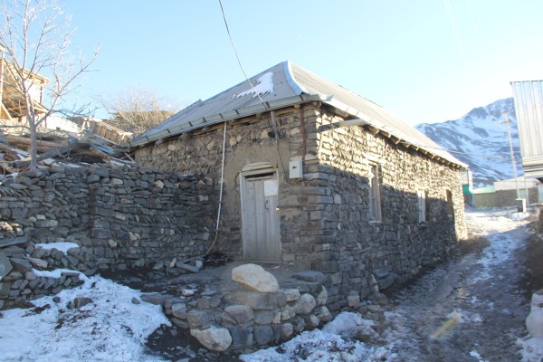
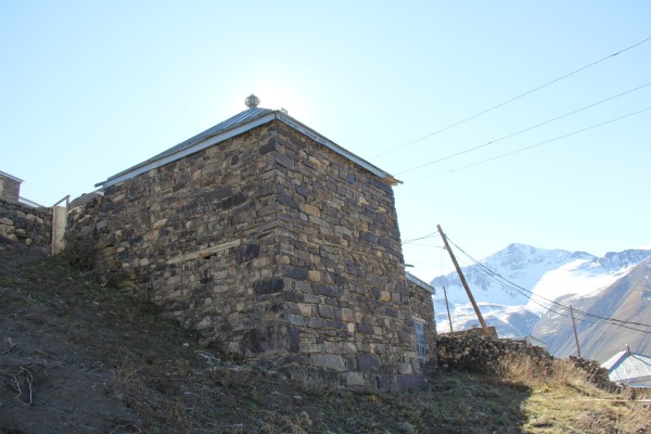
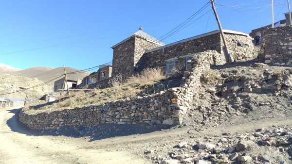
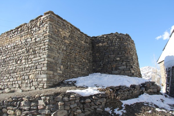
As a locally significant architectural monument (Inv. 4649), this site is under state protection (‘On the approval of the list of state protection of Historical and Cultural Monuments of the Republic of Azerbaijan, decision No. 145 of the Council of Ministers of the Azerbaijan SSR, dated 25 April 1988). The construction date and identity of the builders of the Sheikh Shalbuz Mosque are unknown. In the information published by the Ministry of Culture of the Azerbaijan SSR on 10 February 1987, the construction of the site is mentioned as in the 19th century. However, there is speculation that the shrine and mosque date to the 17th century.

According to information gathered from the villagers, the mosque once functioned as a ‘mollakhana’ or ‘madrasa’. Legend tells of a pious man named Sheikh Shalbuz, who came to Khinalig from Iraq in the 13th century, was an excellent teacher of Islam, as well as the Arabic and Persian languages, and taught students in this madrasa. Sheikh Shalbuz is also said to have had phenomenal awareness and foresight. According to other legends, he could heal patients with his touch.

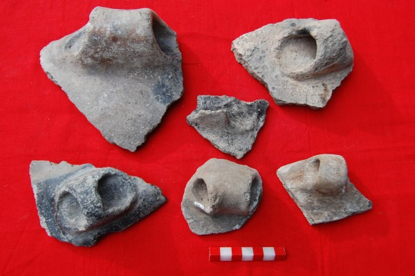
In the tomb where the sheikh is buried, an ancient library fund was found, which suggests that there used to be a religious teaching centre here. From that library, printed materials, numerous manuscripts of the Koran and religious texts from the end of the 19th century and the beginning of the 20th century were discovered. Along with the numerous prayers in manuscripts and writings, medical records were also found. There are several legends about the name of Sheikh Shalbuz in Khinalig. A pier called Sheikh Shalbuz can also be found in Shah plain. In Dagestan, there is a mountain peak that is considered sacred by the Lezgi population in connection with the name of Sheikh Shalbuz. Currently, the villagers come to  Sheikh Shalbuz Shrine and Mosque to pray and make vows during the month of fasting.


Khinalig holds a significant position in the study of Early Bronze and Iron Ages culture within the Caucasus region. Through archaeological endeavors conducted both around Khinalig and within the village itself, it becomes evident that this region has played a substantial role in the cultural evolution of the Caucasus, spanning from the Bronze Age through various developmental stages until the Middle Ages. A closer examination of the archaeological discoveries made in this locale, when compared to findings from other settlements situated on the southern slope of the Greater Caucasus, such as Gabala and Shirvan, suggests the presence of intricate social and political interactions. This underscores the existence of intricate social and political connections within the broader context of the region.

There are 2 caravansary near Salavat village. It is believed that these buildings were built in the 17th century for travelers traveling to and from Gabala. One of these caravansaras, built by digging in the ground, was blown away, and the other was partially destroyed.

The residence is located on a high hill, in the north direction, 5 km away from Khinalig village. It is believed that the monument was built in the Middle Ages in order to prevent an enemy attack from the north.

This ancient settlement is situated 2 km south of Khinalig. It is believed to have served as a control and guard station. The settlement is comprised of two hills positioned adjacent to each other. In the Khinalig language, this settlement is referred to as "Inga," signifying sowing and planting. It is geographically separated from Khinalig by the Gudyalchay river and from the east by the Qiblachay river.

The first hill has a height ranging from 8 to 12 meters and a diameter spanning 30 to 45 meters. In 2012, archaeological investigations led to the discovery of remnants of walls, as well as various pottery fragments at the site. Additionally, an artifact resembling a stone balloon and an assortment of animal bones were unearthed from this archaeological site.

Based on the distinctive features of the pottery found, the site is estimated to date back to the II-I millennia BC.

"Khilels yurdu" is located 300 meters from Khinalyg in the western direction. In recent times, during the construction of administrative buildings and houses in this area, underground walls and the remains of ancient buildings were discovered. This revealed the possibility that there was once an ancient settlement in this area. On the other hand, it is interesting to see the presence of multiple graves on the hill called "Ber-buta" near the area.

This ancient settlement is located 15 km from the village in the south-west direction, on the Salavat Pass, which is the border of Khinalig and Gabala regions.
There are remains of residential buildings in the village of Salavat. There is no information about the number of people living here. There is a cemetery belonging to those people around the buildings. It is possible to go to the monument only by horses or on foot.

"Zangar" archaeological monument is located 10 km southeast of Khinalig village, on the right bank of Gudyalchay, in the foothills, on the modern Guba-Khinalig asphalt road. Since the road once passed through this place, the surface of a large part of the monument has been destroyed. The area of the Zangar monument, located at an altitude of 1963 meters above sea level, is about 2 hectares. As a result of archaeological excavations conducted in the area in 2010-2012, a mound and a settlement belonging to the 3rd millennium BC were discovered. In addition, a hearth from the Early Bronze Age, a layer of ash, numerous pottery, a sharp-pointed blade made of animal bones, a sickle tooth, flint shards, bronze ornaments of various sizes and shapes
(pendants, amulets, earrings, needles, etc.) a large number of beads made of different types of materials (agate, stone, paste, fish ear, etc.) were found. Since Zangar is the first barrow and settlement discovered in the Khinalig area and in the northeastern heights of the Greater Caucasus Mountains, these findings are of great scientific importance.

The ancient cemetery of Kımaliqebriş (means old cemetery in Khinalug language) is located 2 kilometers to the southeast of the village of Khinalig on the right bank of Gudyalchay River. The area is located at 1,968 meters above sea level and occupies over 3 hectares. The place was previously used for grazing.

The archeological site consists of fortifications in the north and stone box graves in the south. The complex occupies an extensive chronological period between 7-5th centuries BC. Up to 40 tombs have been examined. The graves are built with river stone and covered with stone slabs. The corpses were put on their backs facing two directions (east and west), and different decorative and practical objects were buried next to them. It is believed that the items were used in religious burial ceremonies. These include bronze bracelets, beads, earrings, ceramic fragments, glass jars, bells, weapons, and other objects. The phalera with an image of Medusa Gorgona and a fragment of a bronze belt, a shield boss, and a long pelta (a crescent-shaped shield) of Roman origin discovered during the excavations in 2020 have evoked the great interest of the archeologists. These findings testify to Roman expansion in Azerbaijan. Objects of Roman origin have been found in different parts of Azerbaijan (Qobustan, Qabala, etc.) and testify commercial and political ties of Caucasian Albania with the Roman Empire. It is possible that objects of Roman origin passed from hand to hand as booty or at commercial exchanges.

This monument is located 3 km west of Khinalig. The monument is located to the left of Gudyalchay, on a high steep cliff. The stone inscription is on the Khinalig-Gabala road, which was widely used until 1968. Here, a staircase was built to ensure the comfortable movement of horses, oxen, and people. After the stairs there is a small rock platform. In the area adjacent to the square, one of the verses from the Holy Quran is written in the Arabic alphabet at a height of 3 m. This inscription is a symbol of blessing for the travelers who walk through the steep passages to reach the apartment safely. The stepped stone area is an attractive and relaxing place for ecotourism.

Gari cave is located 1 km north-east from Khinalig. The shape of the cave is oval. The internal size is 10 x 10 meters and the internal height is about 10 meters. There is no road to the cave.

As a locally important architectural monument (Inv. 4647) it was taken under state protection. ("Historical and Cultural Monuments of the Republic of Azerbaijan
on the approval of the list of state protection" of the Council of Ministers of the Azerbaijan SSR, dated April 25, 1988, No. 145) the temple "Ateshgah" (in the Khinalig language - "Ce Yuviri jiga-od" - "burning place") is located 5 km north of the village of Khinalig in the direction of Gizilgaya located at the foot of Mt. The area where the flame was created as a result of the natural gas coming from the depths of the earth was considered sacred by the population. Usually, the local population visited the Firehouse with various wishes, and cooked the sacrificed meat on the fire and distributed it as a vow. The building, which is currently on fire, was built in 2016 using rock stone and river stone, traditional building materials of Khinal. The temple is built in the form of a chahar-tagh (an arch facing four directions) in the style of the Surakhani Fire Temple architecture, with a constant source of flame in the center.

"Qirkh Abdul baba" cave is located 1 km north-east from Khinalig. The length is 100 m, the inner width is 5 m, the height is 3-5 meters
varies in range. Pure clear water drips from the ceiling throughout the cave. The local population calls this monument "Kirk per" (Dripping pir). The natural monument is considered a holy place and is visited by religious people.